 |
|
|
|
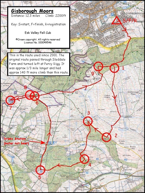
The usual route is clockwise but the race has been run anti-clockwise on a number of occasions. There has also been an extended route, missing out Roseberry Topping and adding a rear ascent of Captain Cooks and Hanging Stone. The first part of the route is slightly diffent to the original classic route (last used in 1999) Current Route (used since 2001):
[S].
Guisborough Rugby Club 617155 (Start) The race starts on the Rugby Club field. It leaves this area via the road and ascends towards the hills on Belmangate. You now encounter a style once you are level with pasture. Carry on heading south until you reaching Guisborough Woods (622148) then climb over a 2nd style and take any route you like to the gate at 616138 [Checkpoint 1] . Go through this gate and follow the minor path south until it joins the main path at 615219. Continue south on the main path to the Sleddale farm entrance at 618120 where you are now back on the classic route so head SW at speed to Percy Cross Rigg Road 613113 [Checkpoint 2] . At Percy Cross Rigg Road the new route (from 1999) turns right for about one Kilometre to the gate at 606118 [Checkpoint 3]. You now descend in a southerly direction to Lonsdale Farm. Here the road ascends to Pale End Plantation. At 605105 [Checkpoint 4] you head in a westerly direction towards Captain Cook’s Monument. Be careful that after about 400m you bear left on the footpath avoiding the wide forest trail. At the Monument 590101 [Checkpoint 5] descend through the forestry on the main trackin a NNE direction. When you reach the car park area at Gribdale go across the road, slightly NE; and ascend the steps towards Great Ayton Moor. Now follow the drystone wall and the fence boundary all the way to Little Roseberry Gate 588127 [Checkpoint 6]. On Roseberry Common you follow a left hand rule. Descend to Roseberry Col. on the main footpath and ascend Roseberry Topping via the ‘stone staircase’. You must touch the Trig. Point at the top 579126 [Checkpoint 7]. Return the way you came up for a very short distance, then follow a marked route that will run parallel to the ascent some short distance to the north. This will bring you through some of the old shale tippings and crosses several ascending paths. You now ascend the steepest part of Little Roseberry, (Roseberry nose) and run along it’s short ridge 586128 [Checkpoint 8] back to Little Roseberry Gate. At this gate do not take the Hanging Stone path but a more easterly path across Newton Moor and Hutton Moor staying on the moor to the south of the fence. At Hutton Moor Gate do not be tempted to drop too low but follow the path along the edge of the fence towards Black Nab and the wall of enclosure around Highcliffe Farm. N.B. All pasture is out of bounds. Follow this wall as it ascends to Highcliff Gate which is encountered as soon as you reach forestry boundaries again. Go through the gate and follow a well used track north. Soon you encounter a main trail, go straight across to the final part of the ascent to Highcliff Nab 610138 [Checkpoint 9]. Now follow the cliff edge for some 200m until you go over a style onto the main forest trail. Keep heading east. After 500m you will see a track left do not descend here but go on a further 300m before descending through Spring Wood. After a very short distance you turn left then right in a ‘zig zag’ This keeps you on the shortest route. On reaching the main forest trail continue in a NE direction to reach the gate at which you entered the wood. Retrace your steps now back to G.R.U.F.C.
------------------------------------------------------------ Original Classic route: (NO LONGER USED - last used 2000)
[S] Guisborough
Rugby Club 617155 ( Start)
The race starts
on the Rugby Club field. It leaves this area via the road and ascends
towards the hills on Belmangate. You now encounter a style once you are
level with pasture. Go over the style and follow the narrow lane up to the
forestry area. On reaching Guisborough Woods (622148) you ascend on the
path that goes directly up! There are two other paths to your left and one
to your right, the latter is the path on which you will return to this
point at the end of the race. After 200M. another track crosses your track
at right angles, go straight across taking the upward route. After 100m there is a right turn into the wood which you should take. Almost immediately this path divides into two and guess what! take the one that goes directly up. This is a steep track which eventually brings you back to the main trail above a very boggy section. Rejoin the main trail turning right and immediately left. There are some gorse bushes to your left here and if you run as close to them as you can whilst rounding this corner of the ascent you will find the least muddy line. So again where there is a choice of path you choose to ascend. This track now swings away east, as you join The Cleveland Way for 200m until it levels out.At this point leave the Cleveland Way and ascend in a general southerly direction to Belman Bank Gate.
At Percy Cross Rigg Road the turn left for 200m then turn right through the gate into the woods. Turn right and follow the path through the woods until the path junction at 607117. You now descend in a southerly direction to Lonsdale Farm and follow the current route (above).
|