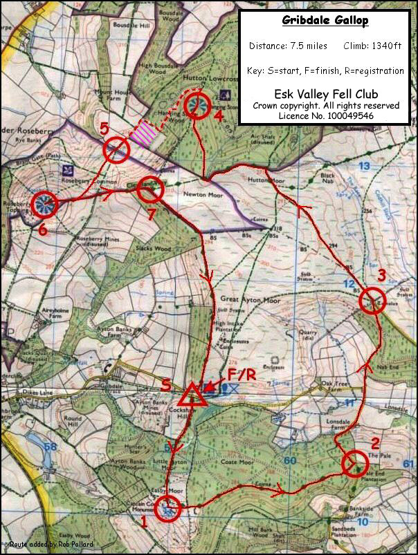
The race
registration / start and finish area is found at the base of Cockshaw Hill
in the car parking area that is over the cattle grid from Gt. Ayton end,
593110. You ascend on the main track to Captain Cook’s Monument
590101 [CP1.] On reaching the monument turn to follow The Cleveland Way in
an easterly direction until you come to the road/footpath
junction at Pale End Plantation 606105, [CP2.] You now follow the
road as it descends first NE then NW past Lonsdale Farm. Go straight ahead
when you pass the outlying buildings of Oak Tree Farm on your left. You
now ascend to the west of Nab End in Lonsdale Plantation continuing in a
general Northerly direction until you come to the path’s junction with
Percy Rigg Road at 607118, [CP3.]
Go through the gate to the road end then through the next gate so that you can continue across the moor in a NW direction . You will pass WW2. derelict buildings at the top of the moor before you descend to Hutton Moor Gate 597129. Go through the gate as if to enter the wooded area but turn immediately west to run along the outside of the wood. You need to continue on this gently rising path until you come to two turn offs that are very close together at 592128. Take the second of these so that you can progress towards Hanging Stone in a general Northerly direction. (In the second year of this event the leaders managed to take the first path and ended up near Hutton Village. Needless to say they were no longer the leaders at the finish.)
At 591133 you will note that this track turns about 270 degrees to head back towards Gribdale. Here you must pick up a very narrow track that runs through the trees in a NNE direction to Hanging Stone Rock, [CP4.]
You can then take ANY route you like from The Hanging Stone to Check Point 5 as long as you didn't cross open pasture.
You now need to
progress to Roseberry Topping itself at 579126 [CP6]. There is no
recommended route across the common it is down to your choice. Having
touched the trig point on the top you now need to progress to Little Roseberry Gate at 588127 [CP7.] The remainder of the route follows the
wall towards the finish passing above Slack’s Wood, High Intake
Plantation and down the steps to the Car Park Area where you started.
N.B.
The original route (no longer used) carried straight
on down from Hanging Stone
Rock to the
‘T’ junction with a wide forest trail at 592136. Headed in a SW direction for a
short distance then continued with this main trail as it descended in a NW
direction between two old quarried areas. Having descended only 100M
it then followed the track that goes SW running alongside enclosed pasture
until it came to the gate onto Roseberry Common at 585131 [CP5]).