| Lordstones / Wainstones (long) Fell Race Route |
 |
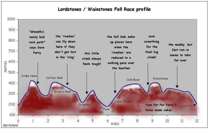
| Race Profile: |
 |
| Route Description: |
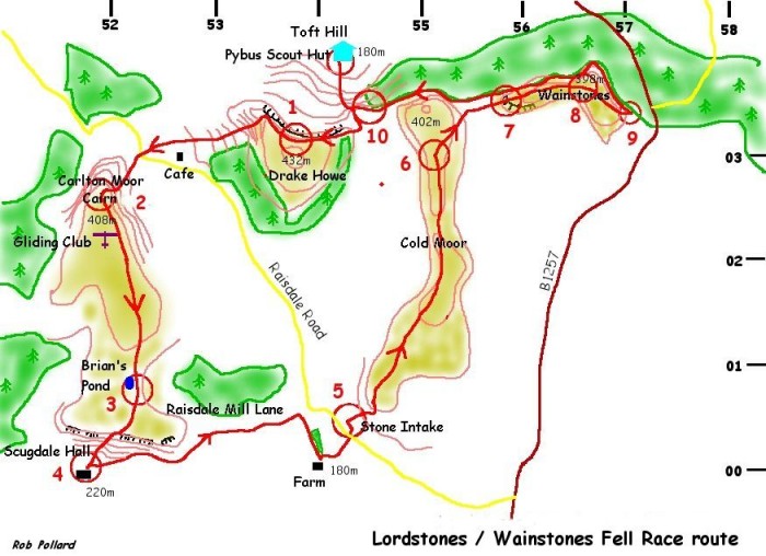
| The route starts at The Pybus Scout Complex ref. 543039; South of Kirkby, Near Gt.
Broughton, Stokesley. The first section proceeds south along a landrover track towards
Kirby Bank. After 500m it bears SE to cross a small re-entrant above the scars. At 544033
the course swings in a westerly direction to CP1 which will be a 'bucket- drop' just to
the North of Drake Howe on the main footpath at 538032. The route now proceeds to the viewpoint at 536033. You will now follow a descent on that dreadful, newly laid, rock path then along a grassy wide track to the road crossing at 523030. CP2 is at the cairn 519026. The route now heads south to the east of the glider station and down to CP3 at Brian's Pond 522007. You now descend through Barker's Crags to Scugdale Hall (CP4 Ref. 518000). The route now goes east for a few hundred metres before climbing to a point at the top of the moor and south of Raisdale Mill Plantation. (532004). The course now proceeds in an easterly direction along the sunken Mill Lane before heading south across rough pasture above Crossletts Farm, at 541002. You now follow the farm road in a north-easterly direction to CP5 at Stone Intake (543004.) You must now follow the footpath across the Bull's field until you are on moorland above pasture areas. approx. 546005. The route now crosses Cold Moor via Three Howes, to CP6 which is at the point where you begin to descend towards the Wainstones climb. (552030.) CP7 is at the top of The Wainstones 560037. This precedes the second 'bucket-drop' of the day at CP8 which is directly north of Hasty Bank Farm at ref. 567030. From here there is a choice of routes to CP9 at the stile (571033), above the steps from Clay Bank Car Park. The route now follows the southern edge of Broughton Plantation, which is a very wide track above Broughton Bank following a general westerly direction to CP10 at the wood corner 546035. After crossing the beck you then continue in a westerly direction for about 200m before descending on the path where you originally ascended. Well I hope that is as clear as mud, as it is the best that you are going to get! Happy hunting! David Parry NECAA. Fell Running Rep. |